It is indeed good to see the NASA Earth Observatory newsletter in my Inbox again, since the shutdown ended. This is one of the things we the people own and pay taxes to maintain, and it’s a wonderful thing, good for all to learn about our world. Even if a person never gets farther than their own downtown, they can still learn about the world with the information we receive from the Observatory. We need to keep the stuff we’ve paid for!
Snippet: We are back! After the lapse in appropriations at the beginning of October, and therefore a lapse in our ability to pay for our newsletter platform, the Earth Observatory team is back to publishing our Image of the Day and we are happy to be back in your inbox. We have a slate of new stories to share with you (I will include them all below so you can catch up) and more planned. But in other news…
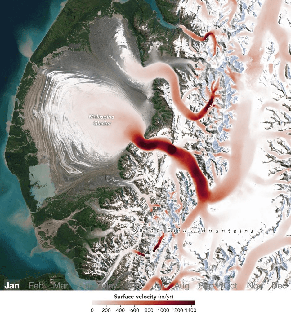
Satellites Detect Seasonal Pulses in Earth’s Glaciers
An incompletely rifted and submerged microcontinent has been recognised tens of millions of years after the tectonic shifts which birthed it began.
Understanding how microcontinents are born may help in disaster prevention during earthquakes.
Ice covered fjord on Baffin Island with Davis Strait in the background. Credit: Image Makers / Photographer’s Choice RF / Getty Images Plus.
The newly recognised microcontinent exists on a tectonic plate boundary between Canada and Greenland which has formed the Davis Strait. This strait connects the Labrador Sea and Baffin Bay.
Scientists have identified a 19–24-kilometre-thick fragment of continental crust about 400km long in the ocean off the west coast of Greenland which has been dubbed the Davis Strait proto-microcontinent.
A study into the microcontinent’s formation is published in Gondwana Research.
The geologists created a reconstruction of the plate tectonic movements spanning roughly 30 million years which led to the proto-microcontinent’s formation.
Proto-microcontinents are defined by the authors as “related regions of relatively thick continental lithosphere separated from major continents by a zone of thinner continental lithosphere.” Lithosphere simply refers to the hard, rocky outer shell of our planet.
They rule out the formation being another feature on the crust, such as a continental ribbon.
Credit: Ianm35 / iStock / Getty Images Plus.
Initial rifting between Canada and Greenland began about 118 million years ago. Seafloor spreading began about 61 million years ago, stopping roughly 33 million years ago to create the Davis Strait.
Between about 58 and 49 million years ago, the scientists say the seafloor spreading between Canada and Greenland shifted from northeast-southwest to north-south. This cleaved off the Davis Strait proto-microcontinent. This seafloor spreading stopped when Greenland collided with Ellesmere Island to the north.
Crustal thickness inversion overlain with proposed extent of the Davis Strait proto-microcontinent. Credit: L. Longley et al / Gondwana Research.
The research can be used to understand how other microcontinents are formed around the world, including the Jan Mayen microcontinent northeast of Iceland, the East Tasman rise southeast of Tasmania and the Gulden Draak Knoll off the coast of Western Australia.
“Better knowledge of how these microcontinents form allows researchers to understand how plate tectonics operates on Earth, with useful implications for the mitigation of plate tectonic hazards and discovering new resources,” says co-author Dr Jordan Phethean from the University of Derby, UK in an article on Phys.org.